Rock Stars After 25 years, W&L faculty member Chris Connors teaches his swan song Spring Term class, Field Methods and Regional Geology of the Appalachians.
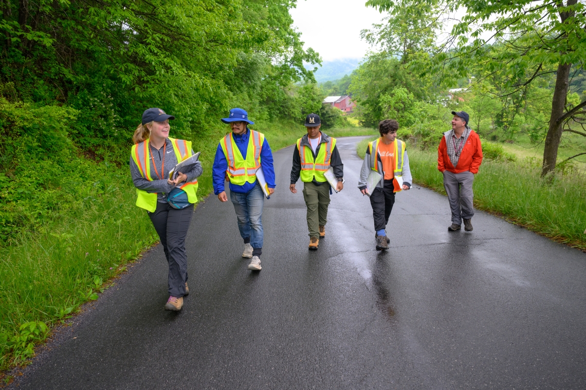
Decked out in reflective yellow vests, the students in the Spring Term Field Methods and Regional Geology of the Appalachians class slowly follow the paved road deep into the cellular service no-man’s land of Rockbridge County while their eyes continually scan the scenery. The green of mid-May in Appalachia means that already sparse outcrops of visible rock prove even more difficult to spot — especially to the non-geologist eye. But Chris Connors’ students know what to look for, and soon they start ducking under tree branches and weaving through brush to get a closer look.
Then the questions begin: What type of properties does this rock have? What are the characteristics? What is this formation? How far does it continue? And where is the contact point — the place where one rock formation ends and another begins?
With pens and clipboards in hand, they work through these questions in pairs and mark on the clear plexiglass covering their given topographic and lidar-derived maps and jot down notes in their yellow field books.
“You’re basically using logic to figure out what rock you’re on,” said Nikola Petrov ’26. “Each rock has a special little thing that everyone knows and can tell apart. So [Professor Connors] basically put us in a place and said, ‘Figure out what differentiates the rocks and draw that.’”
By the end of the week, after spending a few days in the field from 8:30 a.m. to 5 p.m. (or later), they turn in their geologic map to Connors, the William E. Pritchard III ’80 Professor of Earth and Environmental Geoscience.
“The map represents the surface of the Earth; it’s a bedrock geology, so what the rocks are in the area,” said Connors. “Here, there’s not a whole lot of exposure; most of it’s covered in trees or pastures. So [their map is] an interpretation. You get small outcrops, and you get another outcrop, and you make a series of guesses as you’re going along. It’s a challenge with multiple working hypotheses; you carry multiple ideas in your head about what’s going on, and you test them.”
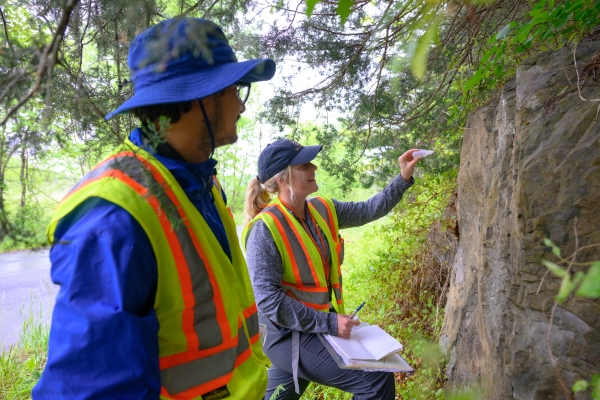 James Edwards ’25 and Abby Portwood ’24 work to identify a rock at Estaline Valley.
Connors took over this course from Ed Spencer ’53, Ruth Parmly Professor of Geology Emeritus, and Fred Schwab, professor of geology emeritus, when he started at Washington and Lee University in the fall of 1999. Unlike many other universities that only offer such “field camps” in the summer — with the majority taking place out West where formations are more visible and easier to map — the W&L Earth and Environmental Geoscience Department felt a commitment to teaching students mapping during the academic year and in the heart of the Appalachian Mountains.
“While field courses based further West are incredible, this field course is truly unique,” said Caroline O’Keefe Bork ’06, who is head of Permian geoscience at BP. “Not many undergraduate programs even offer a field methods course, let alone one in the Appalachians. We saw an incredible range of environments [during what was then a six-week term], including snow in May and exposure to outcrops found in few, if any other, locations on the planet.”
“I feel like one of the main pillars of Spring Term is immersing yourself in the topic, but out of my four Spring Terms — and even going abroad twice — there has been no class like this.” — Abby Portwood ’24
Some regions have flat-lying rock beds, and some are deformed. The Appalachians hold many folds – changes in the orientation of rock layers — and faults, which are breaks in the order sequence of bedrock. Whereas one can generally see the rock layers clearly in the Western U.S., the structures surrounding W&L are anything but flat and are rarely seen fully.
“The rocks are challenging here — then the fact that it’s mostly vegetated and covered makes it harder too,” Connors said. “There have been multiple events that have happened, so a lot of the regional aspect of this course is going through all the mountain-building events and rifting events.
“What I always tell students is: ‘If you can learn to map here in the Appalachians where it’s covered and geologically really complicated, then you can map anywhere.”
By this token, the class has earned a reputation throughout the years of being difficult yet one of the most important courses a geology major can take.
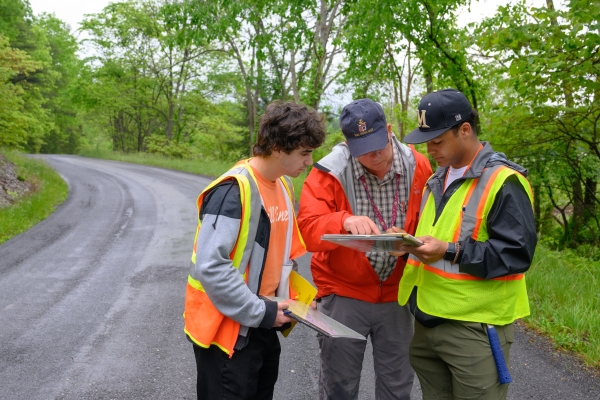 Chris Connors, the William E. Pritchard III ’80 Professor of Earth and Environmental Geoscience, (center) helps Nikola Petrov ’26 (left) and Aden Boyd ’26 with their geologic map.
“I would say that this class is one of the hardest, if not the hardest, class I have taken over the past four years,” said Abby Portwood ’24. “But on that same note, it is just as rewarding. I walked away from the first day of class literally spinning from how much information I learned in just those first few hours, and we have not slowed down since. I think having a professor like Chris who is so genuinely enthusiastic and interested in the subject has a true impact on our enthusiasm and daily approach to the field work.”
“I would consider this class absolutely critical to a geologist’s education,” said Bork. “The skillsets honed through the associated project work and mapping are directly applicable to careers in geoscience. I would also argue that the immersive nature of the course teaches students how to appreciate not just the detail of the science but to be able to pull all that information into a broader, meaningful picture — something that is critical in any career.”
Connors designates each of the four weeks of Spring Term to a different area. The students start out in Buffalo Creek in the Lexington area before taking a camping trip to Germany Valley in West Virginia. The third week, they return to Rockbridge County to map Estaline Valley, a remote area past Goshen. They close out the academic year traveling south to Grayson Highlands State Park in Virginia and Linville Falls, North Carolina.
For all the students in the 2024 Spring Term class, camping together proved to be a highlight. From emerging from their tents at 7:30 a.m. to sitting around a campfire talking and working on their maps until the sun set, it created a sense of camaraderie and brought to life the classroom lectures of previous geology courses.
“Geology is pretty vocabulary-heavy; there are a bunch of words that you’d only use in a geology setting,” said Aden Boyd ’26. “Learning them in the classroom can get overwhelming at times, but whenever we’re out here in the field, you might be using the same word 30 times in an hour. That really helps with understanding and helps nail it in your head and make sure you never forget.
“The camping part [is unique],” he added. “Two separate camping trips, and then cooking together, cleaning together, figuring out stuff together as a class and with the teacher, you definitely get to know each other pretty well — better than most classes.”
And that camaraderie left an impression on alumni as well.
“Every single person helped one another,” Bork said. “No one was excluded; no one was left behind. It was a wonderful microcosm of honor and integrity within Washington and Lee.”
 After 25 years, this Spring Term marks Chris Connors’ last time teaching Field Methods and Regional Geology of the Appalachians.
“We had to draw on a range of skills and knowledge and work together with our classmates to complete a new map over the course of each week,” said Candice Stefanic ’15, a vertebrate paleontologist and anatomist who is completing her Ph.D. at Stony Brook University and will start teaching at New York Institute of Technology this fall. “I definitely learned valuable skills about project management. My favorite part of the course was our overnight trip to West Virginia. We got to camp, and it was a lot of fun hanging out and cooking dinner as a class at the campsite.”
Though James Edwards ’25 already fulfilled his field methods requirement with a different course, he still wanted to take Connors’ Spring Term class because of the esteem in which alumni hold it.
“I try to approach the class with the mindset that I’ll get a lot out of it if I put in the effort, and, in that way, I’d say the class lives up to its reputation,” he said. “It’s hard, but I felt like I learned more in these few weeks than I did in a [longer] term just because of the amount of fieldwork I did. Spring Term allows us to delve into the material in a unique manner that we can’t do in the regular term.”
This year marks Connors’ last year teaching this class as he starts his phased retirement. The move proves to be bittersweet, but the indelible mark he and this class have left on students current and past remains constant.
“I feel like one of the main pillars of Spring Term is immersing yourself in the topic, but out of my four Spring Terms — and even going abroad twice — there has been no class like this,” said Portwood. “I’ve started pointing out local formations and contact boundaries driving the road to Goshen or the back roads around Rockbridge County on the weekends with my friends, and it seems like the sort of skill that you never really forget. It’s also cool to take this class as a senior and be able to really appreciate the beauty and geologic history of the area around W&L as my nostalgia increases approaching graduation.”
“This is the class where it ‘clicked’ for me, and I discovered precisely what I wanted to do professionally,” Bork said. “I went on to a master’s degree in geology and a career in the oil and gas industry, which I still love to this day.
“I can say without hesitation,” she added, “that Chris’ guidance and mentorship changed the trajectory of my life.”
You must be logged in to post a comment.